Name: KĄKOLEWO AERODROME
Aeronautical Information Publication:
https://www.ais.pansa.pl/vfr/pliki/EP_AD_4_EPPG_en.pdf
https://www.ais.pansa.pl/vfr/pliki/EP_AD_4_EPPG_3-0_en.pdf
https://www.ais.pansa.pl/vfr/pliki/EP_AD_4_EPPG_4-0_en.pdf
https://www.ais.pansa.pl/vfr/pliki/EP_AD_4_EPPG_5-0_en.pdf
ICAO code: EPPG
Aerodrome reference code: 2A
Status: public aerodrome with limited certification
Location (according to WGS-84): 52°14’06.33 “N 016°14’27.51″E
Aerodrome elevation: 310ft AMSL
Operations: VFR during the day
Available fuel: Avgas100LL, PB 95
Frequency: Kąkolewo Radio119.935 MHz
Public aerodrome working hours – Tuesday to Friday from 09:00 to 15:00 local time
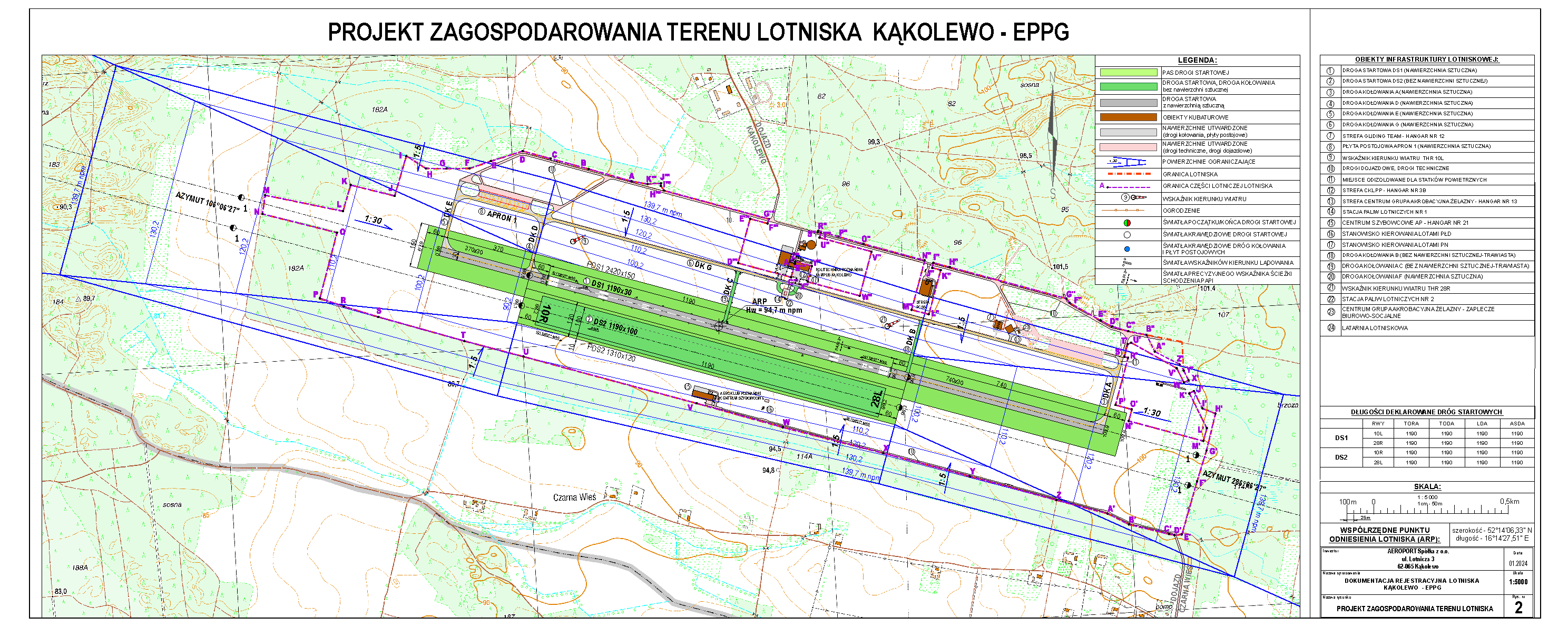
RUNWAYS
| RWY designation | RWY dimensions (m) | GEO / MAG directions | Surface type |
| DS-1 10L / 28R | 1190 x 30 | 106°-286° / 102°-282° | Artificial surface |
| DS-2 10R / 28L | 1190 x 100 | 106°-286° / 102°-282° | Natural surface |
Thresholds on DS-1 are permanently shifted:
THR 10L: shifted towards THR 28R by 370m;
THR 28R: shifted towards THR 10L by 740m.
DECLARED LENGTHS
| Runway No. | Surface type | RWY designation | TORA (m) | TODA (m) | LDA (m) | ASDA (m) |
| DS-1 | Artificial surface | 10L | 1190 | 1190 | 1190 | 1190 |
| 28R | 1190 | 1190 | 1190 | 1190 | ||
| DS-2 | Without artificial surface | 10R | 1190 | 1190 | 1190 | 1190 |
| 28L | 1190 | 1190 | 1190 | 1190 |
AERODROME TRAFFIC CIRCUIT
Direction: left hand circuit
- For DS-1 10L direction of the airplane circuit – north;
- For DS-2 10R direction of the glider circuit – north;
- For DS-1 28R direction of the airplane circuit – south;
- For DS-2 28L direction of the glider circuit – south.
Circuit height: 1300 ft (400 m) AMSL.
Note: in case of simultaneous airplane and glider flights, the south direction of the circuit for gliders and the north circuit for airplanes are dedicated.

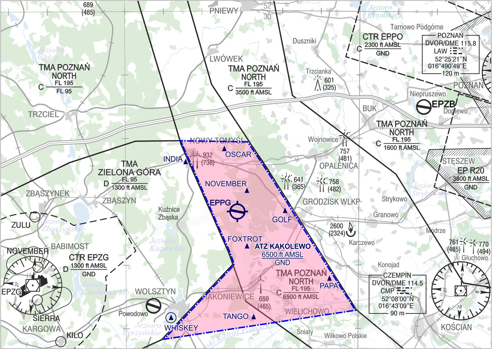
VFR DEPARTURE AND ARRIVAL ROUTES AND POINTS ATZ EPPG
ATTENTION: FROM 18TH APRIL 2024 THERE IS A CHANGE IN ATZ BOUNDARY WITH NEW VFR POINTS
FROM THE NORTHWEST (NW)
INDIA – railway station in Nowy Tomyśl
FROM THE NORTH (N)
OSCAR – church in Sątopy
FROM THE NORTH (N)
NOVEMBER – Sworzyce
FROM THE EAST (E)
GOLF – roundabout in Grodzisk Wlkp. at the exit road towards Nowy Tomyśl
FROM THE SOUTH EAST (SE)
PAPA – palace in Parzęczewo
FROM THE SOUTH (S)
FOXTROT – poultry plant in Wioska
FROM THE SOUTH (S)
TANGO – intersection of parish roads in Tarnowa
FROM THE SOUTH WEST (SW)
WHISKEY – edge of Berzyński lake beside Wolsztyn
AERODROMES AND DIVERSION LANDING SITES
| No. | Aerodrome name/ICAO code | Call sign/Radio frequency | GEO direction from EPPG | Distance (km) |
| 1 | Powodowo landing site | — | 224° | 18,5 |
| 2 | Zborowo landing site EPZB | „Zborowo RADIO” 123.355 MHz | 62° | 30,5 |
| 3 | Zielona Góra Airport – Babimost EPZG | “Zielona Góra TOWER” 118.755 MHz | 250° | 32 |
| 4 | Poznań Airport – Ławica EPPO | “Poznań TOWER” 119.980 MHz | 64° | 45 |
| 5 | Strzyżewice Aerodrome near Leszno EPLS | “Leszno RADIO” 122.305 MHz | 156° | 48,5 |
| 6 | Przylep Aerodrome near Zielona Góra EZP | “Przylep RADIO” 130.780 MHz | 242° | 60,5 |